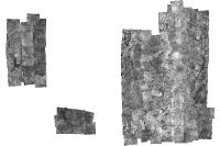
Imagem 1980
Mosaico de fotos aéreas do ano de 1980, baseada em 788 cenas em formato .TIFF, convertida para JPG. Composição Níveis de Cinza (Preto/Branco), com sensor ótico P&B; Pixel de 3X3m
Simple
Identification info
- Date (Creation)
- 2016-09-10
- Date (Revision)
- 2021-11-23
- Purpose
- Subsidiar o planejamento urbano
- Credit
- Não identificado
- Status
- Completed
Originator
Diretoria de Geoinformações Urbanas e Territoriais (DIGEO)
Setor Comercial Norte, Quadra 01, Bloco A - Edifício Number One - Asa Norte - Brasília/DF, CEP: 70711-900
Plano Piloto RA-PP
70711-900
Brasil
- Spatial representation type
- Grid
Spatial resolution
- Spatial resolution
- 2
- Topic category
-
- Imagery base maps earth cover
- Description
- Longitude Limítrofe Oeste: 151160 Longitude Limítrofe Leste: 232503 Latitude Limítrofe Norte: 8277047 Latitude Limítrofe Sul: 8222894
N
S
E
W
))
- Keywords
-
- Language
- Portuguese
- Country
- Brasil
- Character encoding
- UTF8
Content Information
- Attribute description
- Fotografias Aéreas de Sensor Ótico
Distribution Information
- OnLine resource
-
0
FOTO_1980
Resource lineage
- Statement
- Fotografias aéreas de alta resolução, obtidas por sensor óticos, impressas e convertidas para TIFF. Georreferenciadas com base no Aerolevantamento de 1997. Convertidas para JPG e mosaicadas para dispobibilização no Geoportal.
Spatial representation info
- Number of dimensions
- 2
- Dimension name
- Column
- Dimension size
- 1
- Resolution
- 3
- Dimension name
- Row
- Dimension size
- 1
- Resolution
- 3
- Cell geometry
- Area
Reference System Information
- Reference system identifier
- EPSG / 31983
mdb:MD_Metadata
- Metadata identifier
- urn:uuid / 99983e76-d27e-4b74-a29d-696a67d14970
- Language
- Portuguese
- Country
- Brasil
- Character encoding
- UTF8
Originator
Diretoria de Geoinformações Urbanas e Territoriais (DIGEO)
Setor Comercial Norte, Quadra 01, Bloco A - Edifício Number One - Asa Norte - Brasília/DF
Plano Piloto RA-PP
70711-900
Brasil
Type of resource
- Resource scope
- Service
- Metadata linkage
- http://www.metadados.seduh.df.gov.br/geonetwork/srv/api/records/99983e76-d27e-4b74-a29d-696a67d14970
- Date info (Revision)
- 2022-11-17T16:04:16
- Date info (Creation)
- 2020-07-17
- Title
- ISO 19115-3:2014
- Title
- Perfil MGB 2.0
Overviews

Imagem 1980
Spatial extent
N
S
E
W
))
Provided by

Associated resources
Not available
 Metadados - GeoPortal / DF