 Metadados - GeoPortal / DF
Área do PRAD - Pôr do Sol - CODHAB
Camada para registro das Áreas Degradadas em Recuperação, delimitadas durante a elaboração do Estudo Geotécnico e do Plano de Recuperação de Área Degradadas (PRAD), na ARIS Pôr do Sol, disponibilizada no processo SEI 00392-00009107/2022-16.
Simple
Identification info
- Date (Creation)
- 2022-06-08
- Status
- Completed
Originator
- Spatial representation type
- Vector
- Topic category
-
- Imagery base maps earth cover
N
S
E
W
))
- Keywords
-
- CODHAB
- PRAD
- Pôr do Sol
- Plano de Recuperação de áreas degradadas
- Language
- Portuguese
- Country
- Brasil
- Character encoding
Distribution Information
- Description
- Arquivo vetorial no formato ESRI Shapefile (1.0) gerado por rotina diária para dados com atualização contínua.
- Distribution format
-
- ESRI Shapefile
- OnLine resource
-
3
Ãrea do PRAD - Pôr do Sol
Resource lineage
- Statement
- Camada obtida a partir de diversas fontes: Estudo Geotécnico e Plano de Recuperação de Áreas Degradadas (PRAD), vetorização sobre imagem (Geoportal 2015), levantamento de campo.
Spatial representation info
- Topology level
- Geometry only
- Geometric object type
- Surface
Reference System Information
- Reference system identifier
- EPSG / 31983
mdb:MD_Metadata
- Metadata identifier
- urn:uuid / 7f7770a5-3106-44cb-9d9f-90d5e09d90c7
- Language
- Portuguese
- Character encoding
- UTF8
Originator
Type of resource
- Resource scope
- Dataset
- Metadata linkage
- http://www.metadados.seduh.df.gov.br/geonetwork/srv/api/records/7f7770a5-3106-44cb-9d9f-90d5e09d90c7
- Date info (Revision)
- 2022-08-11T15:46:53
- Date info (Creation)
- 2020-10-08
- Title
- ISO 19115-3:2014
- Title
- Perfil MGB 2.0
Overviews
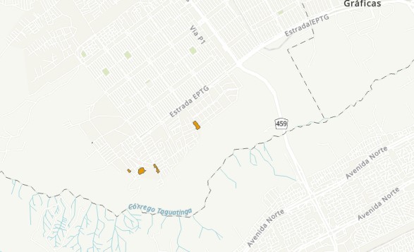
Area PRAD Por do Sol
Spatial extent
N
S
E
W
Provided by

Associated resources
Not available