 Metadados - GeoPortal / DF
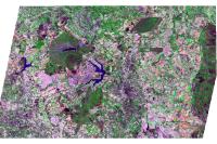
Imagem 1995
Mosaico de Imagem de Satélite do ano de 1995, baseada em 1 cenas em formato .TIFF, convertida para JPG. Composição Colorida (RGB), com sensor multiespectral 4B, com resolução de 20 metros contendo pixel de 10x10m. Obtidas através do Satéllite SPOT.
Simple
Identification info
- Date (Creation)
- 2016-09-10
- Date (Revision)
- 2021-11-24
- Purpose
- Subsidiar o planejamento urbano
- Credit
- Diretoria de Geoinformações Territoriais e Urbanas - DIGEO
- Status
- Completed
Originator
Diretoria de Geoinformações Urbanas e Territoriais (DIGEO)
Setor Comercial Norte, Quadra 01, Bloco A - Edifício Number One - Asa Norte - Brasília/DF
Plano Piloto RA-PP
70711-900
Brasil
- Spatial representation type
- Grid
Spatial resolution
- Spatial resolution
- 0.6
- Topic category
-
- Imagery base maps earth cover
- Description
- Longitude Limítrofe Oeste 148010,00 m Longitude Limítrofe Leste 253027,00 m Latitude Limítrofe Norte 8284851,00 m Latitude Limítrofe Sul 8222744,00 m
N
S
E
W
))
- Keywords
-
- Imagem
- Imagens
- Mosaico
- Fotos aéreas
- Imagens aéreas
- Fotos
- Raster
- Dados Matriciais
- Language
- Portuguese
- Country
- Brasil
- Character encoding
- UTF8
Distribution Information
- OnLine resource
-
0
SPOT_1995
Data quality info
- Hierarchy level
- Service
Resource lineage
- Statement
- Imagem de Satélite de Alta Resolução Espacial, sensor SPOT 4B escala 20000, Controlado pela Empresa SPOT IMAGE. Obtidas por meio de contrato elaborado pela TERRACAP.
Spatial representation info
- Number of dimensions
- 2
- Dimension name
- Row
- Dimension size
- 1
- Resolution
- 10
- Dimension name
- Column
- Dimension size
- 1
- Resolution
- 10
- Cell geometry
- Area
Reference System Information
- Reference system identifier
- EPSG / 31983
mdb:MD_Metadata
- Metadata identifier
- urn:uuid / f0f8b2f1-c006-4a16-b6db-c31a937af9ac
- Language
- Portuguese
- Country
- Brasil
- Character encoding
- UTF8
Originator
Diretoria de Geoinformações Urbanas e Territoriais (DIGEO)
Setor Comercial Norte, Quadra 01, Bloco A - Edifício Number One - Asa Norte - Brasília/DF, CEP: 70711-900
Plano Piloto RA-PP
70711-900
Brasil
Type of resource
- Resource scope
- Service
- Metadata linkage
- http://www.metadados.seduh.df.gov.br/geonetwork/srv/api/records/ff91b5f1-8fe0-44b7-bd52-cec2c7661287
- Date info (Revision)
- 2022-11-17T15:56:17
- Date info (Creation)
- 2020-07-17
- Title
- ISO 19115-3:2014
- Title
- Perfil MGB 2.0
Overviews
SPOT_1995
Spatial extent
N
S
E
W
Provided by

Associated resources
Not available