 Metadados - GeoPortal / DF
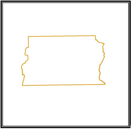
Limite do DF
Limite do Distrito Federal definido pelo Instituto Brasileiro de Geografia e Estatística (IBGE).
Simple
Identification info
- Date (Creation)
- 2019-12-06
- Date (Revision)
- 2021-12-06
- Purpose
- Mapa apontando a proposta mais recente para a delimitação do limite do Distrito Federal.
- Credit
- Instituto Brasileiro de Geografia e Estatística (IBGE)
- Status
- Completed
Originator
Instituto Brasileiro de Geografia e Estatística (IBGE)
- Spatial representation type
- Vector
- Topic category
-
- Planning cadastre
- Description
- Longitude Limítrofe Oeste: 151160 Longitude Limítrofe Leste: 232503 Latitude Limítrofe Norte: 8277047 Latitude Limítrofe Sul: 8222894
N
S
E
W
))
- Keywords
-
- Limite do Distrito Federal
- Distrito Federal
- IBGE
- Instituto Brasileiro de Geografia e Estatística
- Limites
- Limite
- Limites Adminstrativos
- DF
- Distrito
- IBGE
- Language
- Portuguese
- Country
- Brasil
- Character encoding
- UTF8
Distribution Information
- OnLine resource
-
Limite DF
Limite DF
Resource lineage
- Statement
- Não informado.
Spatial representation info
- Topology level
- Topology 1D
- Geometric object type
- Surface
Reference System Information
- Reference system identifier
- EPSG / 31983
mdb:MD_Metadata
- Metadata identifier
- urn:uuid / 1ee3dd30-a093-444e-8329-637bb7e08612
- Language
- Portuguese
- Country
- Brasil
- Character encoding
- UTF8
Originator
Diretoria de Geoinformações Urbanas e Territoriais (DIGEO)
Setor Comercial Norte, Quadra 01, Bloco A - Edifício Number One - Asa Norte - Brasília/DF
Plano Piloto RA-PP
70711-900
Brasil
Type of resource
- Resource scope
- Service
- Metadata linkage
- http://www.metadados.seduh.df.gov.br/geonetwork/srv/api/records/7c6ebdb7-3159-46cd-8719-c444b2643aad
- Date info (Revision)
- 2023-05-03T11:40:13
- Date info (Creation)
- 2020-07-17
- Title
- ISO 19115-3:2014
- Title
- Perfil MGB 2.0
Overviews
LIMITE_DF
Spatial extent
N
S
E
W
Provided by

Associated resources
Not available